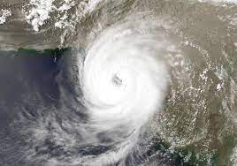
KARACHI, June 12 (EW): The cyclone “Biparjoy” getting much intensity may hit Pakistani shores by June 15, authorities said on Sunday.
High tides may hit Keti Bandar port on June 15. The cyclone is hardly 690 kilometers away from Karachi in South, 670km from Thatta in South and 720km away from Ormara in South East.
The authorities have repeatedly warned the citizens to beware of the gravity of situation. However, warnings fell on deaf ears as people continue to entertain themselves at sea shores.
In its latest Tweet, the National Disaster Management Authority (NDMA) says Biparjoy is now an extremely severe cyclonic storm.
Earlier, the authority issued a warning to the public, urging them to stay away from shorelines as Cyclone Biparjoy approaches the coastal areas of Pakistan and India. The cyclone is currently located approximately 690 kilometres south of Karachi.
The NDMA directed the authorities concerned to run awareness campaign in local language to inform residents of the coastal areas on weather conditions and advise them against visiting the shorelines.
“Fishermen should avoid boating in the open sea. Follow and cooperate with local authorities in emergency situation,” it added.
State-run Radio Pakistan reported that the NDMA advised people to follow the guidance of local authorities in case of any emergency situation. The Karachi commissioner has already imposed a ban on beach access, fishing, sailing, swimming, and bathing within Karachi’s territorial limit due to the potential threat from the cyclone.
Despite the government’s directives, a significant number of people were observed at Karachi’s Sea view, defying the orders to stay away from the shore. However, the police authorities say even there are restrictions on swimming and fishing in the open sea, there are no limitations on visiting the beach.
The Pakistan Meteorological Department (PMD) has officially declared Cyclone Biparjoy as an “extremely severe cyclonic storm.” It is currently situated around 690 kilometres south of Karachi.
The PMD predicts that the cyclone will track further northward until the morning of June 14 before re-curving north-eastward and making landfall between Keti Bandar (southeast Sindh) and the Indian Gujarat coast on June 15 as a “very severe cyclonic storm.” The cyclone is accompanied by maximum sustained surface winds of 150-160 kilometres per hour and gusts of up to 180 kilometres per hour near the centre. Sea conditions are described as “phenomenal” with maximum wave heights reaching 35-40 feet.
The Pacific Disaster Centre (PDC) reported that approximately 1.38 million people from both Pakistan and India are exposed to the cyclone, with 305,755 among the vulnerable population. The PDC forecasts sustained winds of 185 kilometres per hour with gusts up to 232 kilometres per hour.
The PMD has issued warnings about the potential impacts of the cyclone. It predicts widespread wind-dust/thunderstorm rain with heavy falls and squally winds of 80-100 kilometres per hour in Thatta, Sujawal, Badin, Tharparker, and Umerkot districts from June 13 to 17.
Karachi, Hyderabad, Tando Muhammad Khan, Tando Allayar, and Mirpurkhas districts are likely to experience dust/thunderstorms, rains with occasional heavy falls and squally winds of 60-80 kilometres per hour from June 13 or 14 to 16. The PMD advises fishermen to avoid venturing into the open sea until June 17, as the Arabian Sea conditions are expected to become rough with high tides along the coast.
Sindh Chief Minister Murad Ali Shah assured that the government is fully prepared to handle the potential impact of the cyclone. The CM mentioned that the cyclone’s projected path has shifted away from Karachi but identified Thatta, Badin, Sujawal, and Badin as areas at risk. Preparations are being made to evacuate vulnerable families and secure loose structures in those districts.
The public has been urged to avoid beaches during the cyclone, and the government is closely monitoring the situation and providing assistance where needed.
The authorities remain vigilant and prepared for any outcome, emphasizing the importance of caution and planning in dealing with the cyclone’s potential effects.
“#Biparjoy Cyclone is unpredictable yet categorised as high intensity. Panic is counterproductive but caution and planning are better than being caught unawares,” tweeted Minister for Climate Change and Environmental Coordination Sherry Rehman, advising all relevant departments of Sindh and Balochistan to be on ‘high alert’.


